
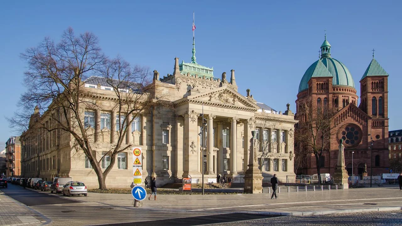
Neustadt Strasbourg: the imperial German quarter, explained
The Neustadt is the planned ring of avenues and monumental buildings that Strasbourg's German administration laid out around the medieval centre after 1871. It is not a separate town and not a museum district: people live and work in it, and much of it is ordinary housing behind grand facades. Treat it as a half-day walk rather than a ticketed attraction, and you will get far more out of it.
What the Neustadt is and why it is worth a half-day
Neustadt is German for 'new town', but in Strasbourg the name refers to a specific historic extension rather than anything recent. The label covers the urban expansion built during the German annexation of Alsace between 1871 and 1918, following an urban plan dated 1880. The city and regional authorities settled on the word Neustadt because it signals both the German origin and the fact of urban growth.
The area earns its time because the set pieces are close together and free to walk past: a formal square, a former imperial palace, a university palace and long planted avenues. What it does not offer is medieval lanes or dense shopping streets, so come for architecture and urban scale, not for browsing. If you have only one full day in the city, this is the natural second half after the cathedral quarter.
Where it sits: the ring around the Grande-Île and the imperial axis
The Neustadt wraps around the historic centre rather than sitting beside it. Its plan was organised around large squares and major traffic axes linking the city to Germany, with the avenues deliberately framing views back towards the cathedral. That geometry is what makes the district easy to navigate: you are always either on a grand axis or in the residential grid between two of them.
For walking purposes, think of a spine running from the Palais du Rhin on Place de la République to the Palais universitaire, with the parallel line of the avenue des Vosges, avenue d'Alsace and avenue de la Forêt-Noire behind it. Place de Haguenau marks the northern end of the planned extension. Start at one end of that spine and walk it once; there is no need to zigzag.
How it came about: the 1880 plan and the German annexation
Strasbourg had considered opening up its fortifications as early as 1840, but a new defensive system was needed first, which stalled the project. After the French defeat in the war of 1870 and the annexation of Alsace, the German administration took up the scheme using plans by the architect Jean-Geoffroy Conrath. The Bebauungsplan adopted on 7 April 1880 placed the new town around the medieval core.
The project had two aims at once: to make Strasbourg a showcase of imperial architecture and to house a fast-growing population. Between 1871 and 1910 the city went from 85,654 to 178,891 inhabitants. More than 8,000 buildings went up in the period, and around 95 per cent of them were put up by private owners, which explains why so much of the district is speculative housing rather than public monuments.
The architecture to look for as you walk
The residential streets are where the district's character actually lives: stone facades in an eclectic Wilhelmian style, bay windows, carved door surrounds and consistent rooflines. Because most of the fabric was privately built, the streets read as a coherent speculative development rather than a set of individual villas. Look at the corner buildings where two avenues meet, which carry the heaviest ornament.
Official recognition of this architecture came slowly. Early listings covered Art Nouveau buildings, most of them privately owned, while the official edifices that symbolised the annexation were only listed from the 1990s: the Palais universitaire in 1990 and the Palais du Rhin in 1993. The listing of the café Brandt in 2014 shows the process is still being extended to everyday buildings.
Place de la République: the civic set pieces
Place de la République, the former Kaiserplatz, is the heart of the monumental district and the obvious place to begin. The buildings around it, together with the university and the station, were built quickly on the line of the old defences. Read the square as a group rather than ticking off single facades: the point is the ensemble and the width of the space.
The square also carries the district's most pointed piece of recent history. The Maison Rouge hotel on Place Kléber, outside the Neustadt proper, was demolished in 1973 despite citizen protests and became the symbol of what not to repeat. That loss is the backdrop to the protection now given to Wilhelmian buildings across the district.
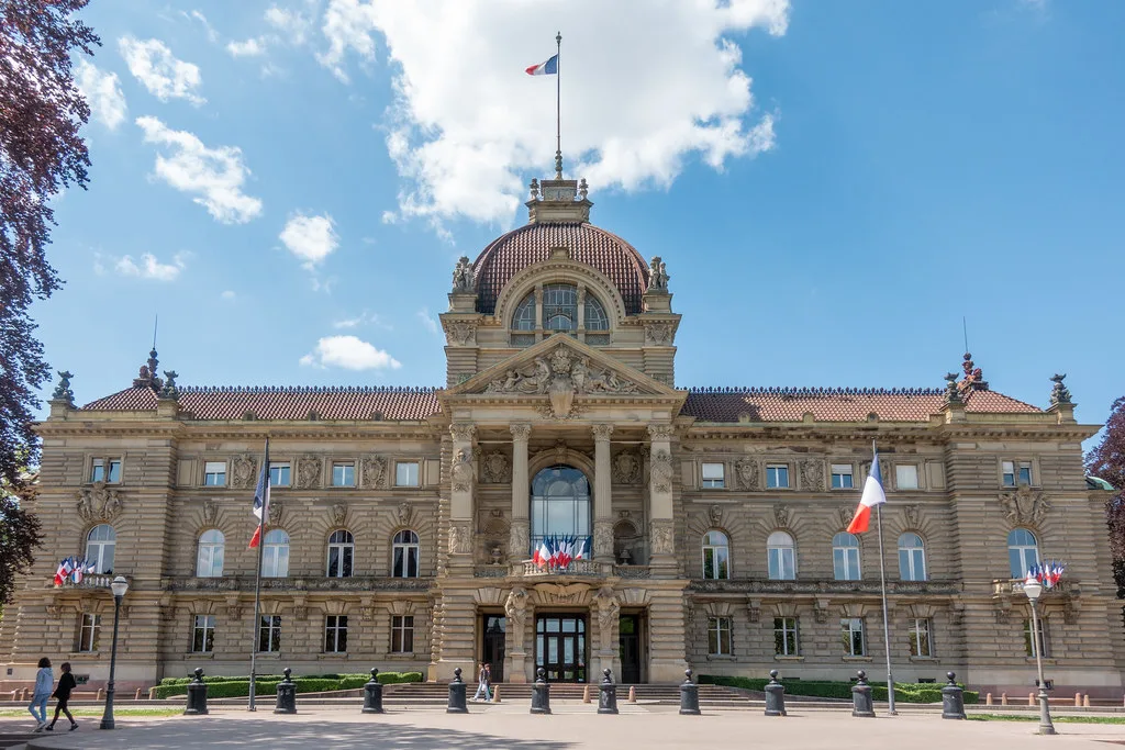
The Palais du Rhin and the Palais universitaire
The Palais du Rhin, the former imperial palace, is the district's clearest statement of imperial power and the building most visitors photograph. It survived demolition plans in the 1950s and was listed in 1993, after the Palais universitaire in 1990. Both are working institutions rather than visitor attractions, so plan to admire the exteriors and the settings rather than expecting to tour the interiors.
Between them, these two buildings define the so-called imperial axis, the stretch that any short visit should prioritise. Walk it in the late morning or late afternoon when the light rakes across the stone, and give it twenty minutes rather than an hour. The reward is the sequence of spaces, not any single detail.
The avenues: Vosges, Alsace and Forêt-Noire
The avenue des Vosges, avenue d'Alsace and avenue de la Forêt-Noire form the second great line of the plan, running parallel to the imperial axis. They are wide, straight and planted, built for movement and display rather than for lingering, and they give the district its distinctly late-nineteenth-century feel. Use them as a return leg so that your walk is a loop rather than an out-and-back.
The historic preservation body Les Amis du Vieux Strasbourg has mapped the area it considers worth safeguarding, from the start of the rue du Fossé-des-Treize to the rue de l'Observatoire, and from the Canal du Faux-Rempart and boulevard de la Victoire across to the Vosges and Forêt-Noire axis. That boundary is a useful mental map for a walk, even though it takes in residential streets beyond the official protected core.
How it became a UNESCO listing, alongside the Grande-Île
The medieval Grande-Île was inscribed by UNESCO in 1988, and the later application sought to extend that recognised area to include the German-built district. The French state submitted the extension file in January 2016. The listing that resulted is joint: it covers Strasbourg, Grande-Île and Neustadt as one urban ensemble rather than the Neustadt on its own.
The Neustadt was added to the World Heritage list in July 2017. It is worth knowing that the UNESCO label brings recognition rather than direct legal protection, and that a parallel revision of the city's preservation plan would bring material protection and access to financial help if adopted. If the status of any specific building matters to you, the UNESCO listing page is the place to confirm it.
Who the Neustadt suits and who should skip it
This district suits travellers who like planned nineteenth-century cities, architectural history and long straight streets with a story behind them. It also works well for anyone who wants a substantial sightseeing walk without paying for a single ticket. It does not suit a family looking for hands-on attractions, or a visitor whose main interest is independent shops and cafés, which are concentrated elsewhere. If planned nineteenth-century towns are your thing, our guide to things to do in Colmar covers another Alsatian old town worth comparing.
If you prefer canal-side streets and a livelier student-and-food atmosphere, the Krutenau is a better use of an afternoon. The two districts are close enough that you can see the Neustadt in the morning and eat in the Krutenau afterwards without crossing the city.
Getting there and walking it in a loop
The Neustadt is within walking distance of the cathedral quarter: from the Grande-Île you cross the ring of canals and boulevards and you are in it. The station area sits directly south of the district, so the Quartier de la Gare is a sensible base if you arrive by train for a weekend. For a loop, start at Place de la République, follow the imperial axis, return along the Vosges and Forêt-Noire line, and finish near Place de Haguenau or back at the station.
Allow around two hours for the loop at a normal pace, more if you stop for photographs at the square. To the north, the Robertsau begins where the planned extension fades into greener, quieter streets, which makes an easy extension of the walk if the weather holds.
Practical trade-offs on timing and pace
The main trade-off is depth against breadth. The Neustadt's highlights are exteriors, so a short visit concentrates on Place de la République and the axis, while a longer one lets you wander the residential grid between the avenues. If you try to cover both in an hour you will see the set pieces and miss the streetscape that makes the district distinctive.
Budget your energy for the walking rather than for queues, since this is a district rather than a site with timed entry. Carry water in warm months and treat the avenues as your shade. Don't schedule the Neustadt as a filler between two museums; give it a clear morning so you can follow the plan's geometry properly.
Plan Your Visit
The Neustadt is best approached as a single coherent walk: Place de la République, the imperial axis, then the Vosges and Forêt-Noire line back. It fits neatly into a Strasbourg weekend alongside the cathedral quarter and the Krutenau, and it costs nothing beyond your time.
Explore more Strasbourg guides
Frequently Asked Questions
What does Neustadt mean in German?
Neustadt means 'new town'. In Strasbourg the name refers to the historic urban extension built during the German annexation of Alsace between 1871 and 1918, not to a modern development.
Why is the Strasbourg Neustadt called the imperial quarter?
It was laid out under the German Empire and includes official buildings such as the former imperial palace, now the Palais du Rhin. It is also called the quartier allemand or quartier impérial, though the city and region chose Neustadt for heritage purposes because it signals both the German origin and the urban growth.
Is the Neustadt part of the UNESCO World Heritage site?
Yes. The Grande-Île was inscribed in 1988 and the listing was later extended to the Neustadt, so the site is now recorded as Strasbourg, Grande-Île and Neustadt. The UNESCO page for the property confirms the current boundary and status.
What should I see in the Neustadt in a couple of hours?
Start at Place de la République, walk the axis from the Palais du Rhin to the Palais universitaire, then return along the avenue des Vosges, avenue d'Alsace and avenue de la Forêt-Noire. That covers the plan's geometry and its main civic buildings without any detours.
When was the Neustadt built?
The urban plan was adopted on 7 April 1880 and construction ran through the annexation period up to 1918. More than 8,000 buildings went up in that time, most of them private housing.
Who should skip the Neustadt?
Travellers wanting hands-on attractions, dense shopping or a food-led afternoon will get more from other quarters. The Neustadt is architecture and town planning on foot, with the highlights largely seen from the street.
How long does it take to walk the Neustadt?
Allow about two hours for the loop from Place de la République along the imperial axis and back via the Vosges and Forêt-Noire line. Add time if you want to explore the residential streets between the avenues.