
Remparts de Beaune: Walking the Old City Walls
The Remparts de Beaune are the fortifications wrapped around the old centre of Beaune, and the practical way to see them is the self-guided Ramparts Walk, a route through 17 remarkable sites: towers, bastions, gardens and old gates. The route is laid out by the Les Amis des Remparts association, with an explanatory sign at each stop carrying a QR code that opens detailed content in French and English on your phone. That means you can plan a route, follow numbered points and read the history on the spot without booking a tour.
What the Remparts de Beaune Are
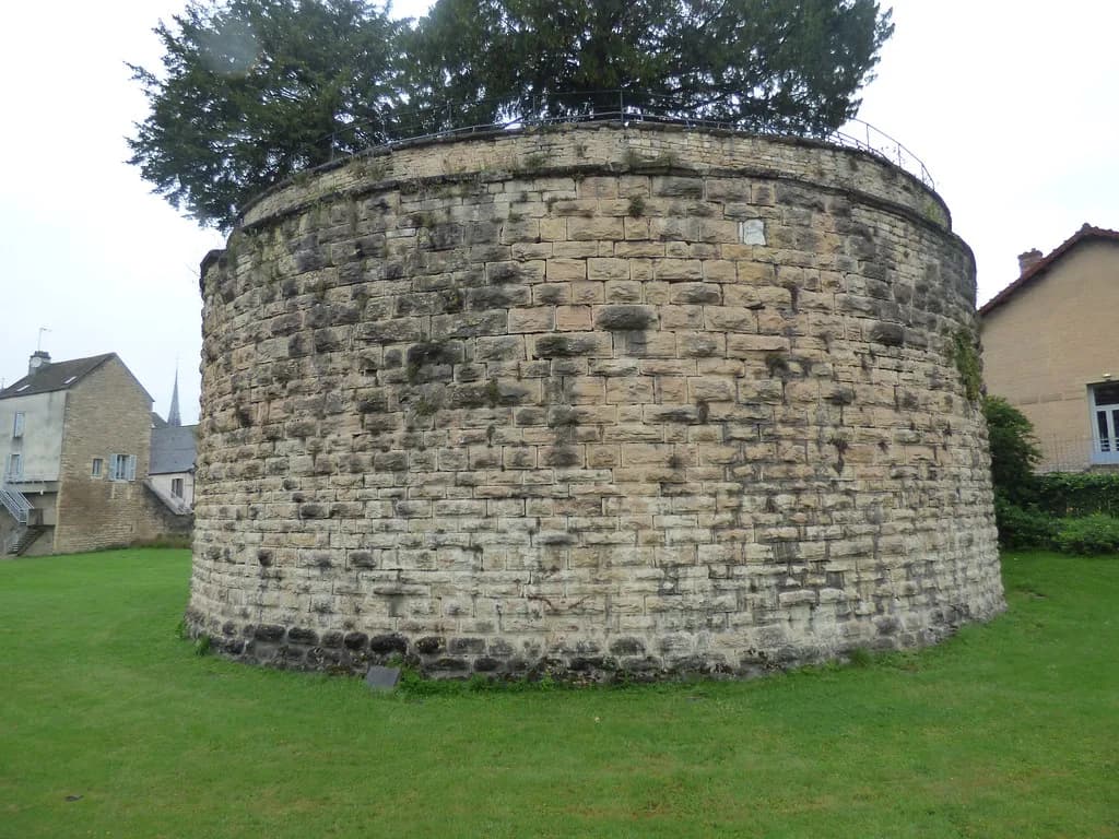
The walls are a defensive ring rather than a single monument: a sequence of towers, bastions, gates and small green spaces that once controlled the approaches to the town. The stops range from 14th-century watchtowers to bastions thrown up in 1637, so the circuit doubles as a timeline of how Beaune's defences changed with artillery. Treat it as an outdoor history walk, not a museum visit, and the appeal depends on how much you enjoy reading fortification detail.
Two building types dominate and are worth telling apart before you set off. Towers are the older vertical structures, often pierced with arrowslits or capped with domed roofs, while bastions are the lower, thicker platforms built to absorb cannon fire and mount guns. Once you can spot the difference, the numbering makes more sense and the later stops stop blurring together.
Where the Walls Sit in Beaune
The ramparts enclose the historic centre, so they sit between the old town and the surrounding streets rather than out on the edge of the city. That makes them easy to fold into a wider day of sightseeing in Beaune, since the centre's main sights are inside the ring. The tourist office lists the walls on RD974 in Beaune, which is the reference to use if you are locating them on a map before arriving.
If you are working out how the centre fits together, Beaune Attractions: 6 Visitor Guides covers the walled core as a whole and shows where the ramparts sit against the town's other sights. Arriving on foot from the station side brings you in near the northern gates, which suits starting the circuit at the eastern defences.
How to Walk It: 17 Stops and QR Codes
The walk is structured, not vague: the association's route passes 17 numbered locations, and each one has a sign with a QR code linking to fuller bilingual content. Download the map from the dedicated site before you start, then use the numbers to keep your bearings rather than zig-zagging between towers. Because the content lives on your phone, a charged battery matters more here than on an ordinary city stroll.
The numbering runs in a logical order around the fortifications, beginning with Tour Renard and the eastern defences before moving through the towers and bastions towards Porte Saint-Nicolas and Tour Blondeau. Follow it as given and you avoid retracing your steps; skip around and you will spend more time walking back than reading. No published source gives a distance or step count for the circuit, so pace yourself by the number of stops you want to read in detail.
Starting at Tour Renard and the Eastern Defences
Tour Renard was built between 1465 and 1477, pierced with loopholes and topped by a domed roof of lava slabs, and it marks the start of the circuit. Its later cameo is unexpectedly grand: on 10 October 1888 it witnessed President Sadi Carnot's triumphal arrival at Beaune railway station. Read the sign here carefully, because the eastern stretch sets up the logic of the defences that follows.
Bastion Saint-Anne comes next and dates from the Thirty Years' War in 1637, built as part of the eastern defences with a direct line of sight over the Route de Seurre and the plain beyond. Standing there makes the strategic point obvious: the town was watching approaches from flat open ground, not mountain passes. This pairing of a 15th-century tower with a 17th-century bastion is the pattern the rest of the walk repeats.
The 15th- and 16th-Century Towers
Tour des poudres is a watchtower from the end of the 14th century that stored the ingredients for making gunpowder, and only its top is visible from the Chemin de Ronde. Next to it, the Grosse Tour is one of four towers built in the early 16th century, decorated on the boulevard side with the coat of arms of the governor of Burgundy, La Trémouille. Look for that heraldry, because it is the clearest marker of who paid for the upgrade.
Tour des Billes, also late 14th century, is a watchtower enclosed within the Grosse Tour, where wood billets for defence were stored, and it overlooks the former postern gate known as Porte Belvent. Tour des Cordeliers is another of the four early 16th-century towers, once part of the Cordeliers monastery whose church was partly demolished to make room for Rue de l'Hôtel-Dieu. Tour des Dames, also early 16th century, has a wall seven metres thick and takes its name from the Cistercian nuns of the Lieu-Dieu abbey installed just behind the walls.
The Lavoir and the Bouzaize Below the Walls
The Saint-Jacques wash-house was built in 1887 at the foot of the ramparts, exactly where the Bouzaize resurfaces after its passage under the Hôtel-Dieu. It is a small, human stop after the fortifications: the sign explains that many washer-women used the lavoir. This is the easiest place on the circuit to picture ordinary town life against the military architecture.
The Bastions of the Thirty Years' War
Three more bastions share the 1637 date. Bastion Bretonnière, also called Condé after the governor of Burgundy, saw the Bretonnière district cheer Queen Christina of Sweden's ceremonial entry in 1656, while Bastion Saint-Martin was later opened up as a promenade by Mayor Maufoux in 1765 and named Square des Lions for the two lion statues at its entrance. Bastion Notre-Dame encloses the small 14th-century Tour Notre Dame, with a stone-domed watch-turret dominating the moat.
Tour des Filles, also called de l'Oratoire, has a seven-metre-thick wall that withstood the new iron cannonballs, and its two names point to the area's twin past of so-called ladies of the night and the College des Oratoriens. The names matter here: they are how the signs identify each stop, and misremembering them makes the map harder to follow.
Porte Saint-Nicolas and the Theatre
Porte Saint-Nicolas is a gate with two lives: the old fortified gate with a drawbridge received many important figures, and since 1770 the new ceremonial gate ordered by Mayor Maufoux has met visitors arriving from the north. Bastion Saint-Nicolas, built in 1569, was demolished around 1800 to make space for a public dance hall called the Vauxhall, which operated until 1860 before giving way to an Italian-style theatre. The Théâtre de verdure stop recalls the bathing facilities once built in the moat of the Rempart de la Comédie.
The Château de Beaune
The Château de Beaune is the largest single piece of the circuit and the one stop worth budgeting extra time for. Louis XI ordered a fortress here both to defend Beaune and to keep watch on its inhabitants, who had sided with Marie, daughter of Charles the Bold; construction ran from 1482 to 1527. That political motive is the most interesting thing about the building, so read the sign before you look up at the walls.
Tour Blondeau, probably built around 1465, is horseshoe-shaped with a vaulted ceiling on a central column and was formerly called Tour du Quarreau. It closes the numbered sequence, so it makes a natural place to stop reading and decide whether to loop back through the centre.
How Much Time to Allow
Allow more time than you would for a simple stroll if you intend to read the signs at all 17 stops, and less if you only want the towers and bastions. The walk spreads across the whole ring, so a half-hearted version still means a fair amount of walking between numbered points. A sensible approach is to pick the stops that interest you most, walk those in order, and leave the rest for a second pass.
If the ramparts are one part of a longer break, things to do in Beaune helps you slot the walk against the town's other sights without overloading a single day. Build the circuit into a morning or an afternoon rather than trying to sandwich it between two museum visits.
Map, Signage and Where to Pick Up the Route
There is a downloadable map on the ramparts site, and the on-the-ground signage at each stop carries the same information via QR code in French and English. Start where the numbering starts, at Tour Renard, or join at the nearest stop to where you are staying and follow the sequence from there. If you want a printed copy, the tourist office listing for the walls is the place to confirm what is available.
Practical Points: Weather, Surfaces and Footwear
This is outdoor walking on and beside old fortifications, so wear shoes you would choose for a city walk of a few hours and take a waterproof layer if the forecast is unsettled. Some stops sit in gardens and open ground, and the lavoir and moat areas are lower and shadier than the boulevard side. None of the published material gives opening hours or ticket prices for the circuit, so check current arrangements with the Beaune tourist office before a special trip.
Nearby After the Walk
The Hôtel-Dieu, the Hospices de Beaune, sits inside the old centre and is the obvious next stop once you have finished the walls; its foundation by Nicolas Rolin and Guigone de Salins is the story most visitors come to Beaune for. Notre-Dame de Beaune is also within the old town and pairs neatly with the northern stretch of the circuit.
If you want an indoor counterpoint, the museum of fine arts gives you a roof and a collection after a few hours of walls and weather. Parc de la Bouzaize, fed by the same stream that resurfaces at the lavoir, is a green place to sit down afterwards.
Who the Ramparts Suit
The circuit suits travellers who like military history, town walls and reading interpretation panels at their own speed, and it works well for a mixed group because you can walk as much or as little as you want. It is less compelling if you want one headline sight with a fixed ticket and a set route: this is a walk past fortifications rather than a museum visit, and the interest depends on the history.
Plan Your Visit
Set aside a morning or afternoon, download the map, start at Tour Renard and follow the numbers around to Tour Blondeau, reading whichever stops catch your interest. Build in the Château de Beaune, the lavoir and at least one of the 1637 bastions, then finish in the old centre. Check the tourist office for current visitor arrangements before you travel.
Explore more Beaune guides
Frequently Asked Questions
How long does the ramparts walk in Beaune take?
No published figure is given for the circuit's length or walking time. The walk covers 17 numbered stops around the whole ring, so budget a half-day if you read most of the signs and less if you focus on the towers, bastions and the Château de Beaune.
Are the Remparts de Beaune free to visit?
The route is a self-guided walk with open-air stops and signage you read yourself, not a ticketed attraction with an entrance. Check current details with the tourist office before a special trip, especially if you are combining it with the Château de Beaune.
Is there a map of the Remparts de Beaune?
Yes. The ramparts site offers a downloadable map covering the 17 stops, and each stop on the ground has an explanatory sign with a QR code linking to bilingual content. Loading the map on your phone before you set off saves time at the first tower.
Where does the Beaune ramparts walk start?
The numbered route begins at Tour Renard and the eastern defences, then continues through the towers and bastions towards Porte Saint-Nicolas and Tour Blondeau. You can also join at the stop nearest your starting point and follow the sequence from there.
Can you walk on top of the ramparts in Beaune?
The circuit follows the fortifications past towers, bastions, gates and gardens, and the signage refers to views from the Chemin de Ronde. It is a walk along and beside the defences rather than a continuous elevated walkway, so expect to move between street level, gardens and moat areas.
What is the Château de Beaune and is it part of the walk?
The Château de Beaune is one of the 17 stops and the largest single element of the circuit. Louis XI ordered the fortress to defend the town and keep watch on its inhabitants, and construction ran from 1482 to 1527.
Do I need a guided tour to see the ramparts?
No. The route is designed as a self-guided walk with bilingual signs and QR codes at each stop, which is enough to follow the history without a guide. Guided options exist separately and can be checked with the tourist office if you prefer company.